Water Diplomacy: The Geopolitics of Shared Rivers
As climate change disrupts rainfall patterns and populations swell, the rivers that cross national borders are becoming some of the most contested spaces in international diplomacy.

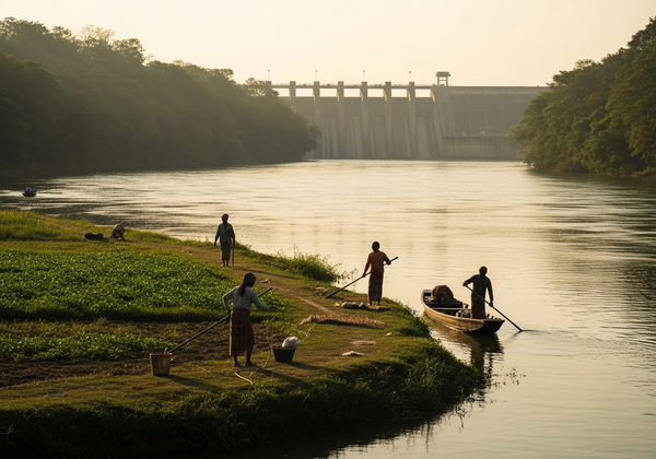
Water, more than oil or minerals, may be the resource that defines the geopolitical struggles of the coming decades. Roughly 60 percent of the world's freshwater flows through river basins shared by two or more countries. Where those rivers cross borders, they carry with them the weight of competing national interests, historical grievances, and the mounting pressure of climate change. The diplomacy surrounding these waterways is quiet, often invisible to the public, but its consequences are enormous.
Rivers That Draw Borders and Blur Them
The Nile, stretching more than 6,600 kilometers through eleven countries, is perhaps the most prominent example of a river as a geopolitical fault line. Egypt, which depends on the Nile for roughly 97 percent of its freshwater, has long asserted what it considers historical rights to the river's flow, rights rooted in colonial-era treaties dating back to 1929 and 1959. Ethiopia, meanwhile, has constructed the Grand Ethiopian Renaissance Dam on the Blue Nile, arguing that it has a sovereign right to harness its own water resources for electricity and development. The dispute between these two nations has at times brought the rhetoric dangerously close to threats of military action.
In Southeast Asia, the Mekong River sustains nearly 60 million people across China, Myanmar, Laos, Thailand, Cambodia, and Vietnam. Upstream dam-building by China and Laos has altered the river's flow patterns, threatening fisheries and agricultural cycles downstream. For Cambodia and Vietnam, where the Mekong Delta is a lifeline for rice production and aquaculture, these upstream decisions carry existential weight.
"Water does not respect borders, and yet borders are precisely where water becomes most politically dangerous. Every dam built upstream is a decision imposed downstream."
The Indus River system, shared primarily between India and Pakistan, has been governed since 1960 by the Indus Waters Treaty, one of the most enduring water-sharing agreements in history. Brokered by the World Bank, the treaty allocated the three eastern rivers to India and the three western rivers to Pakistan. For decades it held, even through wars. But mounting pressures, including population growth, intensified agriculture, and shifting glacial melt patterns in the Himalayas, are testing its durability.
How Water Treaties Work, and Why They Struggle
International water law is built on a handful of principles that sound reasonable in the abstract but prove maddeningly difficult to apply. The doctrine of "equitable and reasonable utilization," enshrined in the 1997 United Nations Convention on the Law of the Non-Navigational Uses of International Watercourses, holds that each riparian state is entitled to a fair share of a shared waterway's benefits. But what counts as fair? A nation that contributes most of the river's flow may see its claim differently from one that has depended on the water for centuries.
Most existing treaties were drafted under hydrological conditions that no longer apply. Rainfall patterns are shifting. Glaciers that once fed rivers reliably are retreating. Aquifers that supplemented surface water are being depleted. The static allocations embedded in many treaties, fixed volumes or percentages, are poorly suited to a world where the total available supply is shrinking or becoming less predictable.
Enforcement is another problem. There is no global water court with binding authority. The International Court of Justice can adjudicate disputes, but only when both parties consent. In practice, most water conflicts are managed, or mismanaged, through bilateral negotiations, regional commissions, or quiet pressure from international donors and development banks.
Climate Change as an Accelerant
Climate change does not create water disputes from scratch, but it intensifies every existing tension. When monsoons arrive late or deliver less rain, the margin for compromise narrows. When glacial melt accelerates, rivers may temporarily swell before entering long-term decline. When droughts grow more frequent, the political cost of sharing becomes harder for any government to bear.
In Central Asia, the Aral Sea basin, shared among Kazakhstan, Uzbekistan, Turkmenistan, Tajikistan, and Kyrgyzstan, offers a cautionary tale. Soviet-era irrigation projects diverted so much water from the Amu Darya and Syr Darya rivers that the Aral Sea shrank to a fraction of its former size, creating an ecological and humanitarian disaster. The post-Soviet states have struggled to cooperate on water management, with upstream nations wanting hydropower and downstream nations needing irrigation.
"The question is no longer whether water scarcity will reshape international relations. It already has. The question is whether diplomacy can keep pace with hydrology."
The Role of Multilateral Organizations
Regional river basin organizations, such as the Mekong River Commission, the Nile Basin Initiative, and the International Commission for the Protection of the Danube River, represent the institutional architecture of water diplomacy. At their best, these bodies provide forums for data sharing, joint monitoring, and conflict mediation. At their worst, they become arenas for posturing, hamstrung by the reluctance of powerful upstream states to cede any authority.
The World Bank, the United Nations Environment Programme, and various bilateral aid agencies also play significant roles, often conditioning development funding on cooperative water management. These financial levers can be effective, but they raise their own questions about sovereignty and outside influence.
Water as a Lens for Broader Tensions
What makes water diplomacy so revealing is that it strips away the abstractions of geopolitics and exposes the material foundations beneath. Nations may clash over ideology, territory, or trade, but water disputes are about survival in the most literal sense. A river diverted is a crop that fails, a city that thirsts, a population that moves.
The diplomatic frameworks that govern shared rivers are imperfect, often outdated, and under strain. But they exist, and their preservation matters. In a world of intensifying resource competition, the quiet work of water diplomacy, negotiating flow rates and reservoir levels, mediating between upstream ambition and downstream dependence, may be among the most consequential forms of statecraft there is.
Understanding these dynamics is not merely an academic exercise. It is a prerequisite for understanding the shape of international relations in the decades ahead.
 Maria Fernandez
Written by
Read next

Arctic Ambitions: Why Northern Shipping Lanes Reshape Global Trade
Receding Arctic ice is opening shipping routes that were once impassable, triggering a quiet but intense competition among northern nations over trade, sovereignty, and environmental stewardship.
The Quiet Rise of African Tech Hubs
From Lagos to Nairobi to Cape Town, a generation of entrepreneurs is building a technology ecosystem that global investors and multinational firms can no longer afford to overlook.
Oman Oasis for Talks? US and Iran Edge Towards Nuclear Negotiation
The United States and Iran have agreed to indirect, Oman-mediated talks on Tehran's nuclear program, marking a cautious but significant step toward renewed diplomatic engagement.
The New Yorker's Political Stage: Podcasts and Local Power Plays
The New Yorker's "Political Scene" podcast and its reporting on the New York City Council speaker race illustrate the magazine's reach from national policy analysis to granular local politics.
The Architecture of Compromise: How Bills Actually Become Laws
The journey from policy idea to enacted law is far messier than any civics textbook suggests, built on committee gatekeeping, back-channel negotiations, and the deliberate architecture of compromise.
Arctic Ambitions: Why Northern Shipping Lanes Reshape Global Trade
Receding Arctic ice is opening shipping routes that were once impassable, triggering a quiet but intense competition among northern nations over trade, sovereignty, and environmental stewardship.